Engineer by day, beadweaver by night (mostly), I like to look for answers to questions.
How do things work? What inspires you? What do you wonder about?
Explore the journey to creativity together.


Showing posts with label travel. Show all posts

Friday, September 9, 2011

Mt. St. Helens

Last week we went camping with several other families.  The highlight of our trip was a journey to get a close-up view of Mt. St. Helens. From where we were camping, we drove up the north fork of the Toutle River to Johnston Ridge.  I was 12 years old when the big eruption destroyed Mt. St. Helens.  I lived just south of Portland, so we did not get the worst of the effects, but I do remember my older brother's baseball games got canceled due to volcanic ash.  I also remember going on a day trip with parents to see the damage.  We drove for hours through miles of a grey, devistated, dead landscape.


This bridge is at the edge of the blast zone.  As you can see, the trees in the area have really grown a lot in 32 years.  This land is owned by Weyerhaeuser, and they replanted the area with noble fir.  The National Volcanic Monument has not been replanted.  Instead, life is being allowed to come back naturally, under close observation by scientists.


We drove all the way up Spirit Lake Memorial Highway to Johnston Ridge Observatory, which is located less than 5 miles from the volcano.  This is as close as you can go without a special permit.  The Observatory is named after David Johnston, the volcanologist who died on duty when the big eruption hit.

The big eruption took place in several quick stages.  First, the top and north flank of the mountain slid down and slammed into Spirit Lake and Johnston Ridge.  The landslide scoured the ridge down to bare stone, then was deflected into the Toutle River valley.  This was the biggest landslide in recorded history.  The water in Spirit Lake was completely displaced, then washed back to settle on top of the landslide, 200 ft higher than it had been before.  Many new lakes were formed by the landslide, including Castle Lake, which you can see in the distance in this picture.


 As soon as the mountain fell, the pressure on all the heated water inside it was released, creating a giant steam explosion called the lateral blast.  The lateral blast was fast, hot and deadly.  It hit Johnston Ridge in about 40 seconds.  The area between the ridge and the volcano used to be old growth Douglas Fir forest.  The lateral blast shattered the trees to splinters.  This photo shows the stump of a shattered tree.


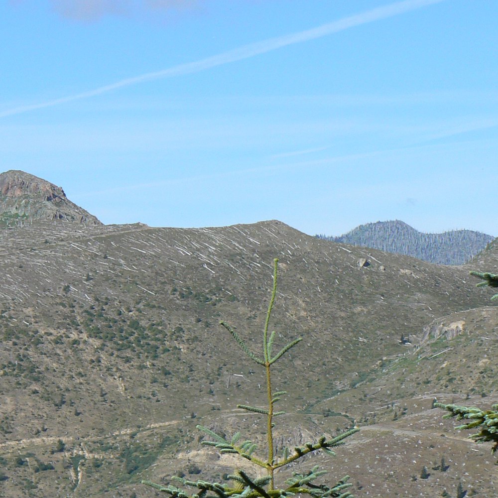
By the time the blast hit the ridge, the largest rocks had dropped out of the blast cloud.  Beyond the ridge, the remaining small rocks knocked over all the trees less than 8 ft in diameter.  Eventually the small rocks dropped out, but the hot gasses continued to expand out, killing another section of forest where it stood.  In the picture below, the trees on upper part of the ridge in the foreground were knocked over.  Behind that, in the background, is another more distant ridge where the trees were killed in place.

After the lateral blast, pyroclastic flows of gassy lava poured out of the volcano.  Mudflows filled the Toutle River and blocked shipping in the Columbia River.  And, of course, ash poured out of the volcano.

What's amazing to me is to see how much life has returned.  In May of 1980, there was still a lot of snow on the ground at this elevation (4400 ft).  The hot lateral blast passed through so quickly that small mammals and trees hidden under the snow survived.  I was surpised to learn from the park ranger that silver fir were big survivors of the eruption.  In the old growth forest, small silver fir would lurk near the forest floor waiting for a Douglas fir to die.  As soon as a path to the light opened up, they would shoot for the sky.  Lots of silver fir survived and are now quickly growing up.


One of the areas that is most resistant to the return of plant life are the pyroclastic flows near the volcano.  The new soil is very nutrient poor.  One plant is making great inroads, though.  Lupine, a relative of the pea that does well at high altitudes, is one of the first plants to move in.  It is able to add nutrients to the soil, so more plants will soon follow.


Mt. St. Helens has continued to erupt since 1980.  The more recent eruptions have built a dome of lava in the crater.  In the close up picture, you can see the glacier that has formed on either side of the lava.  Even though the lava looks like it is steaming, the surface is not hot right now.  The steam is caused by gasses escaping from the volcano.


 The more recent eruptions can still pack a bit of a punch, though, as you can see in this picture.  The twisting piece of metal is a scientific monitoring instrument that got caught in a steam blast.


Visiting Mt. St. Helens really brings home just how fragile life is.  Yet at the same time, life is incredibly resilient.  Even Spirit Lake, which was totally dead and full of mud and ash and dead trees after the eruption, is now thriving with life.  The grey, lifeless hills that I remember right after the blast are now covered with trees and meadows.  Elk, deer and coyote have moved back into the area.


How about you?  Do you know of an inspirational place or story that brings home just how precious life is?
(And, for those of you who made it to the end of this very long post, thanks for hanging in there with me!)

Sunday, September 4, 2011

Camping at Seaquest State Park

We're bug bitten, sun browned and dusty.  We've been camping for a week with several other families.  We stayed at Seaquest State Park in Washington.  Seaquest State Park is located near Mt. St. Helens at the edge of the Cascade Mountains at an elevation of about 500 ft.  The campground is a beautiful forested area, full of tall trees, ferns and mossy rocks.  


The kids loved having that play structure so close (we had around 8 to 10 kids with us as families came and went).  We had 3 campgrounds reserved for our group, so they had a large area to play in without disturbing other campers.

Across the road from the campground is Silver Lake, a nature trail and Mt. St. Helens Visitor Center.  We didn't even have to worry about road traffic because there is a pedestrian tunnel linking the campground to the visitor center.  The visitor center had some really good displays and a great movie.  We did not get to it until our last day, but I kind of wish we had gone there earlier in the trip.

I really enjoyed walking the nature trail, which ran about a mile along the shore of the lake and through a marshy, wetland area.  Here are some photos from the nature trail, which we walked several times.


We saw a huge frog, so big I would have to hold it in two hands.  There were also lots of big, blue dragonflies.  It took me a lot of tries to get a photo of one.  It would hover until I got my camera focused, then dart away when I took the shot.  Dragonflies are very impressive fliers!  There were also a lot of beautiful wildflowers.


We had a lot more adventures and a great day trip up to Johnston Ridge on Mt. St. Helens, but this post is getting pretty long.  I will write about Mt. St. Helens later this week.

Until then, enjoy your labor day!  We will be having a BBQ with our friends.  What will you be doing?

Wednesday, August 17, 2011

Waterfall Inspiration

Several days ago I took a day trip to the Columbia River Gorge with my beading. I shared my travels with all of you, but I never showed you what I made when I was sitting by Horsetail Falls.


 While I was watching and listening to the water thunder down into the pool, I became very interested in the look of the plant life growing on the basalt cliff face.  I liked the texture of the basalt, the line of the water, and in between, trailing along the edge of the falling water, the wildflowers and moss.


I decided I wanted to make something that would capture the way the cliff, the plants and the water all looked together.  The first thing I did was put together some color mixtures.  I had brought at least 12 boxes of beads with 20 colors each to choose from.  Here are my grays and greens.  I was sure to include lots of cube-shaped beads in my grays to mirror the basalt formations in the cliff (maybe I will write a post about basalt sometime - it's very interesting).
Then I was stumped for a while.  How was I going to portray a waterfall?  I had just finished a big project - a necklace inspired by the ocean.  I wanted something a little smaller and simpler this time.  After some mental debate, I decided I wouldn't worry about what my creation would be used for.  I just concentrated on the waterfall and beaded.  Here's how far I got before my legs fell asleep (I was sitting on big fallen rocks at the edge of the pool).
The next day I filled in a little more and added white for the water:

Now that my beading was looking more finished, I once again started wondering what I should make it into. It's really too long to be an earring (although waterfall-inspired waterfall earrings had a certain appeal). Necklaces are really my "go to" comfort-zone type of jewelry, but it felt awkward to try to make this piece into a necklace.  I finally decided that it would be easy to lengthen the random netting and make the piece into a bracelet.  I'm also thinking of adding some semi-precious embellishments, like fresh water pearls in the white (water), peridot in the green (plants) and my favorite stone, labradorite, in the grey (cliff).

What do you think?  Is bracelet a good choice?


Sunday, August 7, 2011

Beading in the Columbia River Gorge

Yesterday I found myself with an unexpected windfall - a whole day of freedom.  My kids went to visit the grandparents and my husband had to work.  Don't get me wrong - I love their company!  It's just that I don't often get to decide how to spend my time by myself, without input from others.  After some debate with myself, I decided to go out to the Columbia River Gorge, which is about an hour from my house to find a scenic spot to do some beading.

The morning was overcast, but warm and dry.  I always feel excited as I enter the Gorge and the cliffs and bluffs come into view.  The Gorge is a huge place.  I decided to take the Historic Columbia River Highway until I found "a good spot".  This highway is beautifully constructed and passes many major waterfalls.  Here are some images of the highway:


The first few waterfalls I passed were impossibly crowded.  Bridal Veil Falls was closed for a wedding.  Wahkeena Falls and Multnomah Falls had absolutely no parking available.  In fact, it was a bit of a traffic jam to get past them.  But the next stopping point was Oneonta Gorge.  I knew it would not be a great place for beading, but it is a really magical place, so I stopped.


I love this place - the tall cliffs covered with mosses, lichens, ferns and wild flowers are amazing.  I was really tempted to get my beading stuff and sit on that log by the stream, but I wasn't ready to settle down yet.

I had been following the trail on the west side of the gorge.  It petered out, so to keep going, I needed to cross the stream.  Unfortunately, I didn't plan ahead for this, and I wasn't exactly wearing water shoes:
Fortunately I made it across without getting wet.  It was a lot of fun to step across from stone to stone.  Once on the other side, I was able to continue down to a big log jam where the gorge narrows dramatically.  It was so worth it!


My next stop was Horsetail Falls.  I love the shape of this waterfall.  It isn't the tallest or the grandest in the Columbia River Gorge, but it sure is beautiful.  I brought my beading stuff down to the edge of the pool and sat down to do the beading.


I spent a couple of hours sitting at the edge of the pool and beading.  People came and went.  One fellow went swimming in the pool.  Most people only go wading because the water is very, very cold.  In the summer streams like this are mostly melted snow and ice running down from the Cascade Mountains.  This fellow was looking for crawdads.  He would catch them, admire them, and then release them.  His dad let me take a picture of one of the bigger crawdads they found.


Eventually my legs fell asleep, sitting on the big rocks at the pool.  It was time to move on.  The sun had come out while I was beading, so I decided to just enjoy the day for a while.

How about you?  What would you do with a day of unexpected freedom?  What places do you find inspiring?


Sunday, July 24, 2011

Beach Adventures

Yesterday I had an adventure. My kids were good helpers when we cleaned out our storage rooms. As a reward I promised to take them to the beach on Saturday with their friends. The weather here in the Willamette Valley just finally turned hot and sunny after one of the coldest, wettest springs on record, so it was a great time to head over the mountains to the beach.


Here is the scene as we picked up our friends. They have a great view from their front yard. You can see Mt. St. Helens as a ghostly presence between the power lines in the center. Yesterday was what our friends call a 5 volcano day - they could see Mt. Ranier, Mt. St. Helens, Mt. Adams, Mt. Jefferson and Mt. Hood.

So we packed up the mini van and headed out - 4 kids, 2 dogs and 1 adult. I knew I was taking on a lot - the Oregon Coast is beautiful, but if you don't respect the elements, it can be dangerous. Follow the rules, and you will have a great time. With kids, they get so excited they will sometimes forget the rules, so you have to ride herd on them and make sure they stay within earshot. Not always easy when you are close to the surf. In any case, the kids all understood they would have to be very cooperative to make this trip work.

At our first stop sign (the intersection of two windy little country roads) we saw a dog running around in the road. It almost got hit several times in the space of a few minutes because it was trying to approach the cars. I parked, got out, and called the dog. It ran right over and jumped into my arms. The dog had a collar but no tags, and obviously came from a loving home. We loaded it into the back of the van so it wouldn't have to interact with my dogs. Here is a picture my son took. The kids and I decided to take it to a local vet. She said she would scan for an ID chip and take it to animal control if needed.

The drive out was very pleasant. It was bright and sunny and we listened to good music. I play a game where I set up the GPS on my phone to monitor our progress toward our destination give it to the kids. They really enjoy watching the map scroll by as we drive.

Finally, we reached the coast! It was beautifully sunny on the west side of the Coast Range too. There were lots of people - it was hard to find parking. Our destination was Three Capes Loop. The tide was out when we arrived, so there was plenty of beach. The kids ate a sandy lunch, then started some engineering projects.

Quick! Build a trench! The ocean is coming! Oh no!


In addition to the engineering projects, the kids chased away the seagulls that tried to eat our lunch, flew kites, got the kites all tangled up, and danced in the ankle-deep ocean waves (under close supervision). I was a little too busy to get photos during this time :) Some of you already know that I love to collect rocks on the beach. I didn't have a chance to do that either, but I did get one picture.


On the way back, we stopped at Cape Meares. The updrafts at the viewpoint were so strong, spray from the surf was sprinkling down on us, a good 200 feet above the ocean! We got a glimpse of a bald eagle, but I wasn't quick enough to get a picture. The kids slept most of the way home. (I had to stop to get coffee for myself). If this wasn't an inspiring (but tiring) day, I don't know what is. I will leave you with some pictures from the view point.